Climate change aside, looking at the subset of empire dynamics only, the situation is quite interesting in its own right. Many good points have been made above. I too feel we are in a post peak empire mode. We are at the same point GB was between world wars, there are areas where we had influence, but that is slipping through our fingers. We are spending a lot of effort to retain that influence, but it is still slipping.
After WWII the accendence of Amercian economic power was evident to all. It was simply clear that the seat of power had moved. This situation was not so clear 20 years earlier when the British were still struggling to hold on. 1937 and 2017 are both murky times.
Churchill could clearly see that bringing American economic power to bear in the war was the solution. Britian alone could not bear the strain against the Axis. The Axis could not bear the strain against America. Churchill clung to his visions of Empire, he knew that as the Empire slipped from the British orb so would Britians wealth and influence. So he hung onto India, and it's markets, for dear life. The war debts and reconstruction costs drained Britian.
The USA was once a the dominant producer nation and the world was our India. As our economy grew we needed bigger and bigger markets and birthed Consumerisim to support our factories. As the economy matured, we switched to a service/financial economy, we relinquished our producer role. In recent years, we have been fighting a costly war of stabilization. The 2008 economic shock caused us to go deeply into debt and invent money and financial tricks to keep the game going.
We're the past cycle to repeat some other nation, such as China or India, would have ursurpped our role by becoming the producers. China moved in this direction but already they are maturing, off shoring their own manufacturing, playing in financials, leasing land outside China to feed Chineese.
So I think this time the cycle will be broken. There is no next empire. What there will be remains a question, whose answer climate change will influence deeply.


PeakOil is You
The Decline and Fall of the American Empire Pt. 2
Re: Peak Empire
![]() by Newfie » Wed 23 Aug 2017, 05:16:01
by Newfie » Wed 23 Aug 2017, 05:16:01
-

Newfie - Forum Moderator

- Posts: 18651
- Joined: Thu 15 Nov 2007, 04:00:00
- Location: Between Canada and Carribean
Re: Peak Empire
![]() by Tanada » Wed 23 Aug 2017, 09:49:16
by Tanada » Wed 23 Aug 2017, 09:49:16
$this->bbcode_second_pass_quote('Newfie', 'T')anada,
I like your approach, but I'm confused. If the tipping point is around 520 and our current CO2e range is as high as 530 doesn't that make the shift possible shortly? On the outside of the range but still there?
I like your approach, but I'm confused. If the tipping point is around 520 and our current CO2e range is as high as 530 doesn't that make the shift possible shortly? On the outside of the range but still there?
Correct, that is why I keep telling people the time for prevention is past and the time to adapt is upon us. Even if the USA were to suddenly decide to go carbon free electricity building windmills and nuclear plants and solar farms everywhere and couple that with synthetic fuel the other 7,200,000,000 people on the planet will still burn enough fossil fuel to push us firmly onto the next step. The cultural inertia of burning fossil fuels is too strong for any other result to take place.
Yes the error bars are very large because the number of variables is very large and each influences
the exact point at which we step up to the 16C world average.
IT! IS! TO! LATE! TO! STOP!
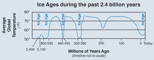
The media does us all a major disservice by portraying climate change as a smooth integral function where we slide up out of major glaciations and smoothly back down. That is a completely false view of reality. When the world is in a major glaciation like it was 25,000 ybp the temperature of the globe cycled up and down a bit and the glaciers advanced and retreated every few thousand years around the margins. Then about 20,000 ybp the change from major glaciation to the current interglacial took one step that was effectively overnight. The only delay was the fact that there was so much ice extending from the poles it took a long time to retreat. People look at this image and they see it took 6,000 years for the massive ice sheets to melt so they think that means the world temperature was slowly rising for that 6,000 years. That is deceptive and incorrect, in reality the world temperature jumped from around 10C to around 13C in a very short period of time but the ice was so massive it took a long time to all melt from that increase in temperature.

World average temperatures meant that in Florida (for example) the climate 15,000 years ago was very close to what it is today, but then over time as the massive glaciers melted half of Florida became drown land tens to hundreds of feet below sea level. In Virginia the climate 20,000 years ago was a lot like Michigan or Wisconsin today, then overnight the climate changed and it became much more like it is today with massive glaciers located just a few hundred miles further north in NYC. Because major glaciations cover a more or less circular area extending from each pole the outermost edge covers a very long perimeter. This means if the ice retreats a mile from its maximum extent it releases a lot more water in the beginning of the melt cycle than it does at the end when the perimeter is much much smaller.
This means to create that mostly smooth integral of sea level rise in the graph the rate of melting had to steadily speed up as the ice extent became smaller and smaller closer to the poles. The cause is believed to be the albedo effect, as the edge moved closer to the poles the area where sunlight was reflected away in summer shrank. However when you are talking about a sheet up to two miles thick for a long time the melting that happens is in the form of thinning, not losing extent. This is the same argument people are having about Arctic Sea Ice today, one person looks at the picture in spring and says the extent or area is almost as large as it was 20 years ago, while another person looks at the sea ice volume and point out while it looks visually similar the actual amount of ice is a tiny fraction of what it was. So the extent shrank very slowly while at the same time every summer the volume shrank a lot more. Only the ice around the edge where the layer was thinnest actually retreated closer to the poles every summer, further inland the glacier deflated a few meters ever summer and then got a fresh dusting of new snow each winter. Because of the surface melting being the predominant way the glaciers melted very large melt water lakes were formed, and as each of these was breached and drained into the world ocean the sea level pulsed higher. Each MWP on the graph means Melt Water Pulse showing when one of these took place.
As the ice edge retreated the newly exposed territory did not revert to tundra like it does when the world average temperature is around the bottom, instead it reverted to prairie or forest landscape within a couple of decades of becoming ice free. It you look at what is taking place in southern Greenland today you can see the same effect.
Check out this graph, over the entire geological history of our planet the world average temperature in Fahrenheit has ranged between 55 and 75 degrees with a few minor excursions here or there. The constant hyping of the idea that if Canada starts averaging 75 F again as it has many times in the past we will go extinct is just plain fear mongering.
Far better to prepare ourselves for that reality, which could happen any time, than to fantasize we can prevent it from taking place. We are past the point of no return. Time to wake up to that reality.
$this->bbcode_second_pass_quote('Alfred Tennyson', 'W')e are not now that strength which in old days
Moved earth and heaven, that which we are, we are;
One equal temper of heroic hearts,
Made weak by time and fate, but strong in will
To strive, to seek, to find, and not to yield.
Moved earth and heaven, that which we are, we are;
One equal temper of heroic hearts,
Made weak by time and fate, but strong in will
To strive, to seek, to find, and not to yield.
- Tanada
- Site Admin

- Posts: 17094
- Joined: Thu 28 Apr 2005, 03:00:00
- Location: South West shore Lake Erie, OH, USA
Re: Peak Empire
![]() by Ibon » Wed 23 Aug 2017, 10:14:43
by Ibon » Wed 23 Aug 2017, 10:14:43
$this->bbcode_second_pass_quote('Newfie', '
')
So I think this time the cycle will be broken. There is no next empire. What there will be remains a question, whose answer climate change will influence deeply.
')
So I think this time the cycle will be broken. There is no next empire. What there will be remains a question, whose answer climate change will influence deeply.
The cycle will be broken. But then again we assume an empire to rise under the context of the past couple of thousand years when technological progress and greater exploitation of resources was always coupled with each emerging empire.
What happens this time is that something may reconfigure but it will not be coupled with exponential resource exploitation and technology gains as in past empires. So this raises the interesting question. Assuming we will preserve scientific knowledge this will be applied to any cyclical new empire but in an ecological environment and resource base that will be diminished. Doesn't this force any new empire to adapt another set of cultural regulations?
Every past empire for the past couple of thousand years emerged in this cyclical pattern with greater technological inventions at their disposal and greater energy exploitation and a biosphere of still unexploited resources.
How does a new empire adapt with science preserved but a diminished ecological resource base?
Doesn't self regulation of consumption and population become a higher priority under these circumstances? This assumes of course that some new empire emerges.
Otherwise there will be a lot of small tribal communities thriving in the monumental shadows of our ruins much like the Mayans who were living in grass mud huts in the shadows of their ruined pyramids when the Spanish first came to the New World 500 years ago.
Patiently awaiting the pathogens. Our resiliency resembles an invasive weed. We are the Kudzu Ape
blog: http://blog.mounttotumas.com/
website: http://www.mounttotumas.com
blog: http://blog.mounttotumas.com/
website: http://www.mounttotumas.com
-

Ibon - Expert

- Posts: 9572
- Joined: Fri 03 Dec 2004, 04:00:00
- Location: Volcan, Panama
Re: Peak Empire
![]() by Ibon » Wed 23 Aug 2017, 10:24:23
by Ibon » Wed 23 Aug 2017, 10:24:23
$this->bbcode_second_pass_quote('Tanada', ' ') When the world is in a major glaciation like it was 25,000 ybp the temperature of the globe cycled up and down a bit and the glaciers advanced and retreated every few thousand years around the margins. Then about 20,000 ybp the change from major glaciation to the current interglacial took one step that was effectively overnight. The only delay was the fact that there was so much ice extending from the poles it took a long time to retreat. People look at this image and they see it took 6,000 years for the massive ice sheets to melt so they think that means the world temperature was slowly rising for that 6,000 years. That is deceptive and incorrect, in reality the world temperature jumped from around 10C to around 13C in a very short period of time but the ice was so massive it took a long time to all melt from that increase in temperature.
Enjoyed that post Tanada. That ice acted like a big sink of energy stored in a flywheel or a battery which is what permitted that slow rising for 6000 years. As you point out there is no stored sink remaining today to moderate change. This is why we can fully expect an inflection point with accelerated changes coming very very soon in geologic terms, even in human life time terms. There is no base line normal that we will return to in the foreseeable future
Which institution in the private or public sector has anything to gain from explaining this to the mass of humanity.
Crunch time on a global level
Patiently awaiting the pathogens. Our resiliency resembles an invasive weed. We are the Kudzu Ape
blog: http://blog.mounttotumas.com/
website: http://www.mounttotumas.com
blog: http://blog.mounttotumas.com/
website: http://www.mounttotumas.com
-
Ibon - Expert
- Posts: 9572
- Joined: Fri 03 Dec 2004, 04:00:00
- Location: Volcan, Panama